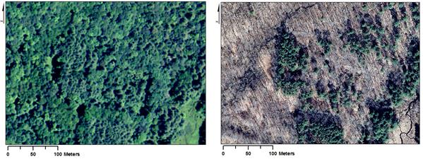
Aerial imagery source: Connecticut Environmental Conditions Online (CTECO)

Source: UConn Libraries Map and Geographic Information Center and CT State Library (1934) and USDA NRCS (2010 LiDAR)
This is an ongoing research project to understand how people have shaped the history and development of southern New England’s landscape. Although the landscape reached the height of agricultural use in the early 19th century, much of that land has now become reforested, obscuring cultural features beneath the forest. LiDAR allows us to identify and analyze cultural landscape features and interpret them within a broader historical, geographical, and archaeological context to understand the human impact on the landscape’s history and development.
People working on this project:
Robert Thorson (collaborator)
Publications related to this project:
Johnson, K.M. and Ouimet, W.B.. 2016. Physical properties and spatial controls of stone walls in the northeastern USA: Implications for Anthropocene studies of 17th to early 20th century agriculture. Anthropocene 15: 22-36.
Johnson, K.M. and Ouimet, W.B.. 2014. Rediscovering the lost archaeological landscape of southern New England using airborne Light Detection and Ranging (LiDAR). Journal of Archaeological Science 43: 9-20. (Citations)(Altmetric Score)
Abstracts and presentations related to this project:
Johnson, K.M. and W.B. Ouimet, 2016. Investigating the spatial distribution of 18th to early 20th land use dynamics in Connecticut and implications for the Anthropocene in southern New England. Poster presented at the American Association of Geographers meeting, San Francisco, CA. April 2016. Abstract
Ignatiadis, M.E., W.B. Ouimet, K.M. Johnson, and D.P. Dethier, 2016. Charcoal remains in Litchfield County,Connecticut record widespread hillslope disturbance in the iron corridor from mid-18th to early 20th centuries and present day carbon storage GSA Abstracts with Programs 48(2). Paper to be presented at the Geological Society of America Northeastern Section meeting, Albany, NY. March 2016. Abstract
Johnson, K.M. and W.B. Ouimet. 2015. “Impacts of terrain roughness on 18th-20th century land use distribution and sediment mass transfer in southern New England” GSA Abstracts with Programs 47(7):239. Paper presented at the Geological Society of America national meeting, Baltimore, MD. November 2015. Abstract
Ouimet, W.B., D.P. Dethier, K.M. Johnson, M. Kotikian,and W. Wicherski. 2015. “Quantifying 18th to early 20th century human impacts on hillslopes and sediment mobilization in southern New England and Colorado Front Range.” GSA Abstracts with Programs 47(7): 240. Paper presented at the Geological Society of America national meeting, Baltimore, MD. November 2015. Abstract
Johnson, K.M., and W.B. Ouimet. 2015. “Quantifying the Anthropocene: the Physical and Cultural Controls on Stone Wall Construction in Southern New England,” Paper presented at the Association of American Geographers meeting, Chicago, IL. April 2015. Abstract
Johnson, K.M., W.B. Ouimet, and Z. Raslan. 2015. “Geospatial and LiDAR-based analysis of 18th to early 20th century timber harvesting and charcoal production in southern New England,” Paper presented at the Geological Society of America Northeastern Section meeting, Bretton Woods, New Hampshire. March 2015. GSA Abstracts with Programs 47(3). Abstract
Ouimet, W.B., and K.M. Johnson, 2014. Use of LiDAR to analyze fine-scale ground features in southern New England. Paper presented at the 9th Annual Native American Archaeology Roundtable, Institute for American Indian Studies, Washington, CT. 8 November 2014.
Ouimet, W.B., K.M. Johnson, M.M. Hill. 2014. Historical Archaeology, Historic Human-Environment Interactions, and Land-Use Dynamics in Southern New England Using Aerial LiDAR. Poster presented at the annual meeting of the Geological Society of America, Vancouver, Canada, October 2014. GSA Abstracts with Programs 46(6): 96. Abstract
Johnson, K.M. and W.B. Ouimet. 2014. “Butted and bounded as followeth”: LiDAR and the historical division of the landscape in southern New England. Paper presented at the annual meeting of the Society for Historical Archaeology, Quebec, Canada. January, 2014.
Johnson, K.M. and W.B. Ouimet. 2013. Uncovering the past: GIS analysis of archaeological features under New England forests using high resolution topographic data (LiDAR). Poster presented at the Northeast ArcGIS User group meeting, Amherst, MA. May 2013. Won NEARC poster award. (DOWNLOAD PDF)
Johnson, K.M. and W.B. Ouimet. 2013. “Archaeological applications of LiDAR in southeastern New England.” Paper presented at the Geological Society of America Northeastern Section meeting, Bretton Woods, New Hampshire. March 2013. Abstract
Ouimet, W.B. and K.M. Johnson. 2013. Uncovering the past: Mapping and exploring networks of stone walls under New England forests using high resolution topographic data (LiDAR). Paper presented at the Association of American Geographers meeting, Los Angeles, CA. April 2013. Abstract
Press related to this project:
National Geographic, “‘Lost’ New England Revealed by High-Tech Archaeology,” 3 January 2014.
http://news.nationalgeographic.com/news/2014/01/140103-new-england-archaeology-lidar-science/
Science, “Lasers Unearth Lost Agropolis of New England,” 10 January 2014.
http://news.sciencemag.org/archaeology/2014/01/lasers-unearth-lost-agropolis-new-england
Associated PodCast: http://news.sciencemag.org/scientific-community/2014/01/podcast-new-england%E2%80%99s-lost-civilization-surviving-nuclear-apocalypse
- Syndicated from above to the Huffington Post.
National Public Radio (NPR), “Where We Live,” 13 January 2014.
http://wnpr.org/post/language-mental-health-50-years-anti-smoking-efforts-archaeology-tech-uconn
(Third segment of the show ‘Where We Live’ on WNPR, Connecticut. Kate’s interview starts at minute ~36:00)
Archaeology Magazine (online), “LiDAR technology maps New England’s Colonial past,” 6 January 2014.
http://www.archaeology.org/news/1697-140106-lidar-colonial-new-england
Archaeology Magazine (print), “Peeping through the Leaves,” May/June 2014 issue.
http://www.archaeology.org/issues/132-1405/trenches/1974-new-england-lidar-colonial-landscape
LiveScience.com, “New England’s ‘Lost’ Archaeological Sites Rediscovered,” 16 January 2014.
http://www.livescience.com/42642-new-englands-lost-archaeological-sites-rediscovered.html
Additional Graphics made available: http://www.livescience.com/42638-lost-new-england-archaeology-lidar-photos.html
- Syndicated from above to CBS News and Yahoo News.
GISLounge, “LiDAR and the archaeology revolution,” 14 January 2014.
http://www.gislounge.com/lidar-archaeology-revolution/
Newport Daily News, “High-tech archaeology focuses on local sites,” 22 January 2014.
http://www.newportri.com/newportdailynews/news/page_one/high-tech-archaeology-focuses-on-local-sites/article_d8dcd939-bae0-5646-85e7-6d5a5deebfe7.html
UConn Today, “Hidden New England Landscape Comes to Life,” 18 February 2014.
http://today.uconn.edu/blog/2014/02/hidden-new-england-landscape-comes-to-life/
Sakonnet Times, “High-tech tool reveals our lost villages,” Vol.48, No.8, 20 February 2014.
http://www.eastbayri.com/news/high-tech-tool-reveals-our-lost-villages/
ecoRI news, “Technology Reveals Hidden New England Heritage,” 21 March 2014.
http://www.ecori.org/smart-growth/2014/3/21/technology-reveals-hidden-new-england-heritage.html
University of Rhode Island,“Big Thinkers,” 10 April 2014.
http://ww2.uri.edu/who/kate-johnson-06
Providence Journal, “Uncloaking the ruins of Rhode Island’s ‘lost civilization'” – editorial by Timothy Ives, Principal Archaeologist, RIHPHC, 16 April 2014.
http://www.providencejournal.com/opinion/commentary/20140416-timothy-h.-ives-uncloaking-the-ruins-of-rhode-islands-lost-civilization.ece
ScienceLine, “Reading Human History from the Land”, 28 March 2016
http://scienceline.org/2016/03/reading-human-history-from-the-land/
NASA Spinoff, “For a Glimpse of the Stone Age, Some Cutting Edge Tech”, 22 Nov 2016
https://www.nasa.gov/directorates/spacetech/spinoff/feature/glimpse_of_stone_age
Social Media: